New Route for me in the local hills, in fact I’m calling my favorite route to date. All areas I had been to before, though mostly in the winter, I had just never linked it all together. I started in the pre morning dark at the Wheeler Canyon Trail Head and ran gorgeous single track up toward Snow Basin Ski area. Once in the ski resort, I followed a combination of mountain bike trails and service roads up the top of the John Paul chair lift and the on to the peak of Mt Allen, from there I traversed the ridgeline south, hitting all the other peaks and high points along the way. I felt good this morning and was excited to be able to run every step of the initial 4000 ft, 10.5 mile climb, all the way to the peak of Mt Allen. I don’t know what it is about maintaining a run to a high peak, even a slow run, that makes the top that much more gratifying.
Here are the details in pictures:

Looking up at the route from Ogden Valley. Mt Allen is the peak on the right, I ran across the skyline, hitting Mt allen first, then Mt Ogden (highest, just left of Allen), Needles, DeMosiey, and Stawberry Peaks. The route starts below the low green hill in the foreground.

Running up the service road and looking up at DeMoisey Peak.

Still headed up, Mt Ogden and Allen with wild flowers!

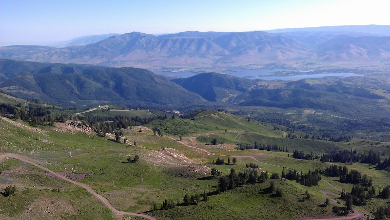
View from the top of Mt Ogden looking down to the start. The trailhead is right next to Pineview, the lake you can see in the distance.

Looking North from Mt Ogden back toward Mt Allen, the first peak I got to. North beyond that is Lewis, Ben Lomond and Willard. Such an awesome place to be able to run everyday! The service road I ran up is visible in the lower right, near the start shack for the Women's Olympic Downhill.

After leaving Mt Ogden, I traversed South to Needles Peak and then on to DeMoisey Peak, pictured here. The whole run through this section is right on the ridgeline like this, just freaking awesome!

Looking South again from DeMosiey Peak toward Strawberry Peak.

Looking back toward the start/finish from Stawberry Peak. The trail head is at the bottom of the canyon shadowed in the top/center. Lots of sweet downhill run'en from here.
Run stats: 23.5 miles, 5800 vert, time 4:50 (moving) Pace 12:15.
Exactly what I wanted from this run, to feel comfortable at an all day, 100 miler pace.
http://connect.garmin.com/activity/104531591
Oh, and if you haven't seen this....pretty freaking incrediable!
http://www.youtube.com/watch?v=NFCjaKhbHMk&feature=player_embedded
|