All right....it's been a while so I'm lumping alot into one post and this my be the longest post ever on FRB, but I included pictures so at least that part should be entertaining.
Last I left off I was getting ready to start the Bighorn100. Thanks for the well wishes before the race, but I didn't end up going. Things came up at work the week before and there was no way I could have left town and run a big race without getting some resolution.
Things did resolve to a point where I felt like I could go late Thursday afternoon. I really wanted to run, put a call in to the Goat and had him ask the race officials about a late check in. While waiting for him to call back, I completely packed for the race, including drop bags, in less than an hour. Goat called back and I was ok to check in on Saturday morning, but, understandably, they couldn't gurantee my drop bags would make it to where they needed to be. I knew others running, and I knew a few had crews, but something about driving 8 hours, starting a 24 plus hour race with out knowing for certain I had drop bags where and when I needed them left me not really wanting to put out that much energy on an unsure outcome.
Truth told, my knee wasn't 100% so the odds of actually finishing where low anyway. Goat did well and finished strong as did several others I knew running. Hated to miss it, was one of may favorite races last year, but there will be more races. Besides, had I run I would have missed out on what I was able to run over the last week, which I would have traded Bighorn for in a minute.
First off, I had an absolutely incrediable run up Ben Lomond last Saturday. First time up this year. I left the trailhead with no watch, a water bottle and a gel. I love how light I am able to travel now. A few years ago this outing was a 70 ounce Camelback and a packed lunch. I left the car just after 9:30 and ran every step up perfect trail to the summit marker. It felt effortless and I never pushed a bit. Curious, I pulled out my Ipod to check the time, I made the top in 1:37, give or take a minute as I was basing it off the time in the car. Pretty decent for me.
A few cruiser runs early in the week around the local trails then I was off to Driggs, Idaho for work on Wednesday afternoon. Last time I was up there a snow storm kept me from exploring the trails in the area, so I was really looking forward to getting in some running, with the ultimate goal being to summit Table Mountain, which is a peak directly above Driggs and directly West of the Teton massif.
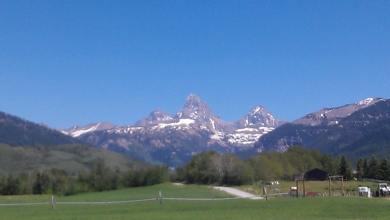
(View of the Tetons from where we are working in Driggs)
(Table Mountain is the flat peak top-center)
Wednesday evening, I got out on an explroatory run on a trail up Teton canyon on gorgeous single track through aspens and pines in the fading light. A few miles in, I ran into a couple of moose who refused to yeild the trail. Noise, banging sticks, nothing, they would trot up trail around the next corner and stop. After a couple rounds of that I decided not to press my luck and headed out, getting back to town just in time to take my guys out for some of the best Mexican food I've ever had. Gotta love Driggs.
The next moring I was off fairly early to run up Table Mountain. I had heard a lot about this peak. Gorgeous hike with stunning, up close views of the West side of the Tetons, so I was excited to give it a go. I had glanced at a map, and it seemed there was one way up, and it was the trail I was on the night before.
All started off well, then after three miles or so the trail took a turn that required wading a fairly stout creek that was running full from snow melt. A couple of freezing steps in, knee deep, then thingh, then waist deep for a couple of steps. Freezing! I had to repeat the crossing a couple more times as the trail continued up river.
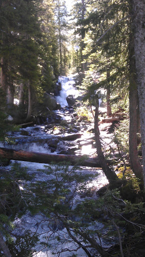
(Freezing creek I had to wade)
A mile and a half later the trail took a turn into a large north facing basin that was covered in snow. The trail disapeared and after a bit, footprints in to snow faded out as well. I knew where I needed to go. I could see the peak, I just needed to figure out a way to negotiate the terrain to avoid the many steep, icy snow slopes above.

(Snow filled basin. Table Mountain is the peak on the horizon)
I made my way up exposed boulders and mostly dry groud to the ridge just below the peak. I hadn't seen a soul all day, but as I got to the ridge I noticed two people about a half mile away, walking toward the peak from the west. I wondered where they had come from and if they had followed the actual trail.

(view of the Tetons from the top of Table)
The views from the peak were better than I thought. Tetons close enough you could almost make out people on the lower saddle. Sheer drop to the east down into Alaska Basin, looking northeast to the top of Cascade Canyon. Best of all, a clear view of the Southwest couloir route on the Middle Teton. That got my wheels spinning.
As I left the peak, I asked the couple still walking up where they had come from. They said the "Face route" and that it was snow free. All I had to do was follow the flat ridge for a mile or so and I would run into the trail. They warned me it was steep. I took off happily trotting along the flat alpine ridge, noticed a trail in the hillside a mile or so away and set course for that spot. As I started down the trail proper, I ran into tow guys hiking up that wanted to know about the snow up high. I noticed he had a handheld GPS, so I asked how far to the parking lot. He looked and said 1.4 miles. I thought, sweet closer than I thought. Then he looked again and said "and it's 2800 vertical feet." What?! I thought no way could a trail be that steep, maybe a bushwack, but not an actual trail. I said, "wow, that's steep." he very casually looked up from under his camofluge ball cap, pulled a bandanna out of the pocket of his of his jeans, wiped his forehead and said "ya, pretty much straight down from here" Gotta love Teton Valley folks. Straight down it was, I don't htink I've ever run an established trail so consistently steep. Literally straight down not hardly a turn let alone a switchback.
Spent the afternoon working and considering my running options for the next day. I really wanted to get to a properTeton peak. The Southwest route on the Middle looked like the best option. I was going solo, so needed something non-technical and the snow that is still lingering in abundance in the range limited alot of other options. By 7 o'clock I was loaded up and driving over Teton Pass, hoping to make it to Teton Mountaineering before they closed at 8:00 so I could pick up a new mountain axe. I wasn't planning on a high peak when I left home, so I didn't bring anything for snow climbing. I was o.k going light, but an axe is pretty much required minimum equipment for an early season climb in the Tetons.
I slept in the dirt next to my truck right at the Lupine Meadows trail head. I set my alarm for 4:30, but was pretty suprised to wake up at 4:15 and find twilight on the east horizon and enough light to see clearly. I felt tired, didn't want to get up in the cold morning air, so I rolled over and fell back to sleep unitl 5:00.

(Beautiful morning starting up the trail)
Waking up, I stuffed down a cold breakfast, tried to shake off the grogginess, stuffed a couple of gels in my pockets, my lightest windshell in my Nathan pack along with a light pair of liner gloves and a hat. I was at a bit of a loss about what to do with the ice axe. With a proper pack I could attach it using the axe loops and be on my way. No such thing on a Nathan runnnig pack. Luckily I was feeling inventive and happened to have the hardware to make the modification. I now have what may be the first Nathan mountaineering pack.
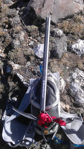
(modified Nathan, Jacket sinch straps and a small hole in the top with some tie wire to hold the shaft upright. Held perfect running, couldn't even tell it was there)
I was able to make pretty quick work of the trail leading up to the meadows area. Amazing how much easier that trail feels when your not hauling a rope and climbing rack. Rounding the corner into Garnett Canyon has to be one of my favorite places in the world and the Middle Teton is front and center.

(Garnett Canyon and the Middle, might be heaven on earth)
Reaching the sign and creek crossing at the meadows, I was shocked to see how much snow was still hanging on. The snowfields were all the way down to the creek. Snow coverd the south facing wall above Spalding Falls, and it looked like it was solid snow all the way up the the saddle between the South and Middle Teton's. I sat on a rock for a bit and thought through things. I was in running shorts, a light shirt and trail shoes. Not really equipped for a icy snow climb, would seem crampons would have been a minimum addition to my gear list.
I decided to start climbing the snowfields and see how it went, but told myself I wouldn't push it at all and if the snow as too hard or steep for running shoes I'd turn around. Pleased to find the intial slopes soft enough that I could get pretty could bite in my shoes and my new axe added a little security in the sketchier sections.
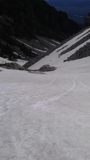
(Looking down the intial snow slopes to the meadows, this was taken on the way down)
I plugged along to the saddle and got my first good look at the Southwest couloir, I was really hoping it was snow and ice free. Looking up the route, all looked passable. There were some snow patches, but looked like I could pick my way up the steep slopes on mosltly dry ground. I also got a good look at Table Mountain from the other side, couldn't belive it was just yesterday I had stood on that peak.

(looking across at Table from the saddle)
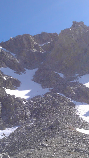
(Looking up the Southwest Coulior to the peak . The route follws the rock ribs in the center of the pic to the v shaped notch in the rocks where it steepens (read: got sketchy) and climbs to the summit, feeling good here, my Garmin has been beeping low batery for a bit, I made to to here in 2:40)
I made my way up the inital slopes of the final pitch and felt great. I was surprised by the steepness of the terrain. It reminded me of the climb to the upper saddle on the Grand, but slightly steeper. The wind was starting to rip pretty hard from the west, and I was totally alone on the mountain, which was fine, but the solitude and roaring wind did it add a bit of a creepy element to things, knowing if I blew it in any way I may be there for a while before someone came along.
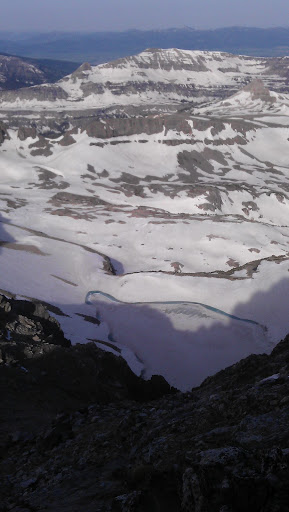
(Looking down into Alaska Basin from about half way up the Coulior. Notice Summer ice lake (? I think that's the name?) still frozen far below. This is just below the "crux". Rock'en some Chilli Peppers "Higher Ground" on the Ipod at this point)
About 2/3's the way to the peak I looked up and my heart sank a bit. I knew there was a steep section right before the top that I recalled from climbing this same route 15 years earlier. I was now looking at the section I remebered only it was filled with a ice and rock hard frozen snow. I would guess the steepness at 45-50 degrees, with broken up rock slabs on both sides. It was only maybe 200-300 vertical feet, but enough that a slip above halfway up without being able to self arrest would almost certainly end in injury or worse.
I started up, just to see how it would feel. The running shoes weren't cutting it. Even lite crampons would have made this section simple, but felt sketchy in shoes. I decided to scranble on the rock next to the snow. I took off my gloves and started to climb. The terrain was easy, but definatly 5th class. These were not happy moments. I knew if I blew anything, it would be a short, but uncontrolled fall onto the ice, then a fast out of control slide to the rocks. There were a couple of moments where I had to really tell myself to stay calm and relax.
Within a few minutes it was over and I was scrambling up the last bit to the summit. The top of the Middle Teton is a crazy place. It's no bigger than a sofa a drops nearly vertical on 3 sides. I was cold, the wind was ripping, and I was still prety freaked about reversing the sketchy section on the way down. Needless to say I didn't stay long. I looked at my Garmin to see how long it took me to summit, dead! Damnit! I pulled out my phone to snap some pics and noticed it was 8:47, so around 3.5 hours.

(looking at the Grand from the top of the Middle)
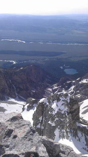
(looking East down Garnett Canyon from the summit. Trail starts left of the lake)
Heading back down, I got back to the crux, scrambled down the rock to a point where I didn't feel comfortable down climbing. I ventured tentatively out onto the snow slope by sinking my axe all the way to the adze and trying to step in the frozen sun cups in the snow. I'd get a secure palce for my feet and move my axe down as far as I could, and kick my feet down again. I down climbed the snow this way. It was slow, but felt much more secure than climbing on the rcok, I should have gone up the same way.
Soon enough I was back in the warm sun and cruising down the rock and snow feilds back to the meadows. I had great fun glisading down the now super soft snow. I passed a few parties on their way up to the Middle. They were all decked out with crampons, gators, big packs, axes, all the gear. I felt like a bit of a goof running by in my shorts and short sleeve shirt skating along in my running shoes with an axe rigged to the back of my running pack.
Getting back to the Meadows, I found a dry spot, sat down a relished to view for a bit. Such a stunning place, surrounded by huge peaks and waterfalls. Everytime I climb out of Garnett Canyon, I always feel a bit giddy when I get back to the creek in the meadows area. The stress of the climb melts away and the joy fully sets in. Same feeling I get at the finish line of a hard race.
I relaxed for a bit then took off to run the four miles back to the parking lot. I cruised the trail a hard as I could while still trying to take it somewhat easy on my freshly healing knee. I felt great and still had plenty of energy all the way out. I hit the lot and looked at my phone again, I had made the round-trip in 5:20 or so, wasn't sure to the exact minute I left the lot. I jumped in the truck and drove straight to the Jenny Lake boat launch and walked straight into the lake and sat down, much to the shock of the nice family from Iowa sunning on the rocks. Soaking in Jenny lake is always the reward for a hard day in the Tetons.
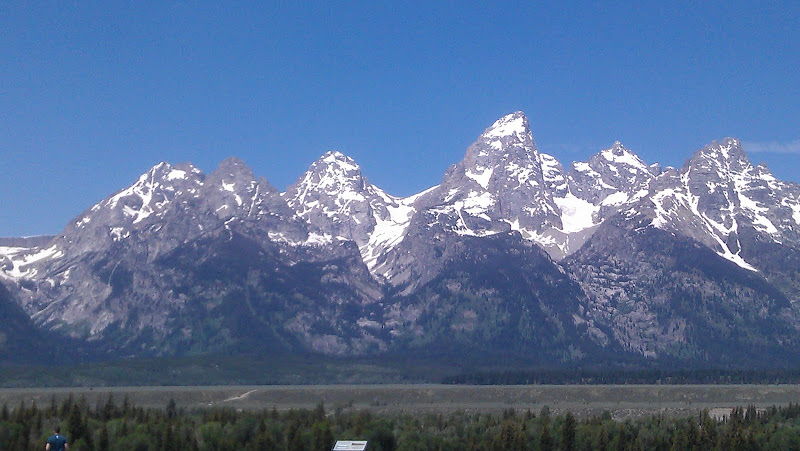
(The classic Teton view. I took this from the highway on my way home. The Middle Teton is the peak left of the tallest one in the center which is the Grand Teton)
Got out for an easy hike to Malan's basin today. Three peaks in three days, my kind of a week.
Stats sum up from Saturday to Saturday:
Miles: around 55
Vert: 19,250 ish
Knee: holding up ok though not 100%. ART Sean thinks its a tight quad and glute medius that is causing the trouble, rather than a tendonitis or brusitis, so working it isn't making it worse as long as I take care of the knots in the muscles.
|