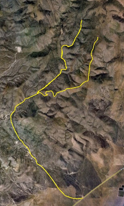
On the South side of Lake Mountain are three different access roads to the top. I've gone up and down the one furthest to the west several times, that being the main road. I thought I would try the route in the middle, perhaps going almost to the towers and then take the main road back south. Well, it didn't turn out that way, but I had a great time in the early morning in the snow on the mountain.
I started at 4 a.m. at Redwood Road and ran up Soldier Pass road, almost to the pass. The temperature was about 30 in the lowlands, so all the mud was frozen. The road I wanted turns right, just before the switch back to the top of the pass. The middle route stays down in a canyon, so I was successful in easily staying on the right route. But as I approached 6,000 feet, the snow started to get deeper. I stopped to put on my microspikes and then could make better progress. But as I reached 6,400, the snow drifts in the small canyon really made things slow and soon I was just doing post-hole hiking. That was OK, it looked like I was almost to the top of the ridge. But then my canyon narrowed and looked like it was ending. I guessed I had missed a turn (I believe I did). Since I was going so slowly, I turned back and tried to find my missed turn, but never noticed it in the dark.
So, when I reached the junction for the eastern route up, I decided to go take that one. I knew it would be much steeper and it was. This route quickly climbed up the slopes and they were bare of trees and thus free of snow for longer. Dawn was arriving as I reached the top of the ridge and had amazing views to Cedar Valley to the west, the Tintics to the south, and Utah Lake to the west. But once again, as I reached 6,400 feet, the snow slowed me down. I continued on because the view were spectacular as the sun started to rise. Fog blanketed Provo across the lake and it was heading my way. Once I reached 6,600 feet, I believe I made it to the junction where my first route should have climbed to the top of the ridge too. At that point my toes were really getting cold going through foot-deep snow, and I just had a little slush left in my bottle (it had frozen, probably about 20 degrees up there). So, I turned around. I was glad that I found a nice new training route. Doing a loop of those two routes would be nice because the first one is down in the trees and the second has wonderful vista views. This will be fun once the snow melts. The route on top continues along the length of the top of Lake Mountain to the towers on the north side.
With all my exploring, I traveled about 20 miles in 4.5 hours. Not speedy, about 4,000 feet of climbing with lots of snow.

|